- 2007
- SDG&E lines ignited the Witch, Guejito & Rice fires
- ~$2.4B
- Paid to settle those fire claims
- 45,000
- Evacuated in Fallbrook, De Luz & Rainbow when SDG&E's 2007 Rice Fire burned this back-country
Crippled firefighting — the response itself is thwarted
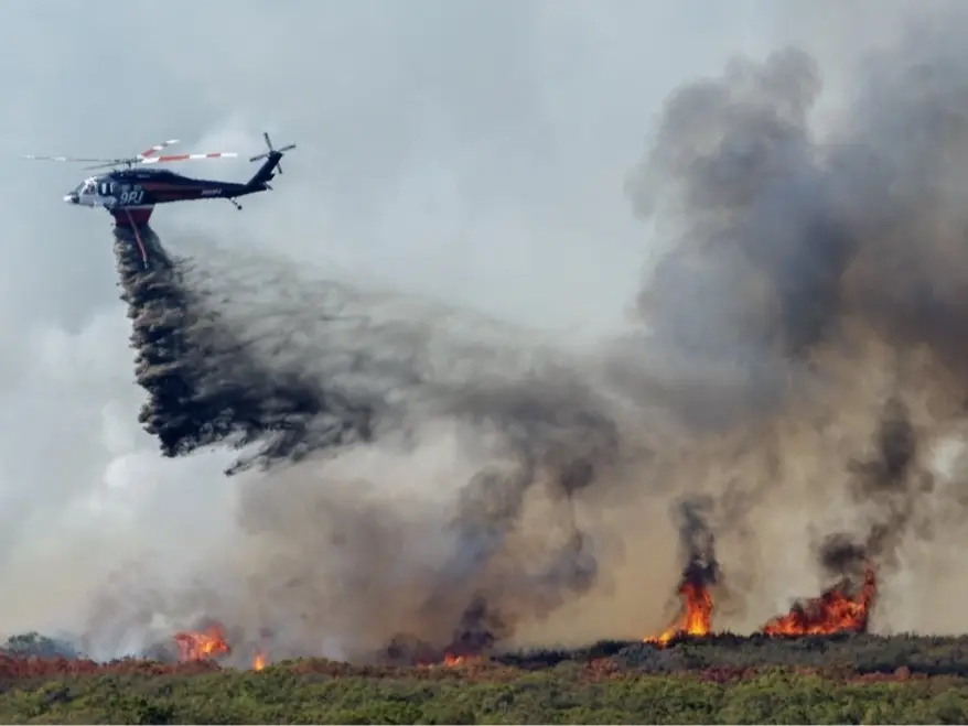
For five miles, this line would thread the Temecula Creek corridor through the populated south of the city. [5] [4] When a wind-driven fire reaches homes like these, the knockdown comes from the air. But firefighting guidance treats high-voltage lines as an aviation hazard aircraft must keep clear of, so a 500 kV line strung the length of the creek draws a no-drop zone over the exact streets it runs past. [1] [3]
On the ground, the line does worse than block the planes — it holds the firefighters back. The rules force crews to abandon a direct attack within 100 feet of a transmission line until it is de-energized — and no one on the fireline can do that. A 500 kV line isn't switched off at a pole: it is fed with live power from substations at both ends, so only SDG&E's grid-control center can open the breakers feeding it, lock out the automatic reclosers that would snap it back to life, and send a crew to physically ground it — and until the company confirms all of it, the wire has to be treated as live and lethal. So as a fire bears down on these streets, the crews holding the hoses can do nothing but call SDG&E and wait for someone at a control desk miles away to free them to fight. That wait is the same for any energized line — and longer for a 500 kV line fed from both ends, which no local switch can kill. It was real at the January 2025 Eaton Fire: even for ordinary neighborhood wires, crews were told over the radio that, per their Southern California Edison contact, the lines were “to be considered energized, even wires that are down,” and that the utility “currently do[es] not have a plan to mitigate this issue tonight.” [7] [8] [9]
Blocked escape — out down a few narrow roads
And if a fire does push toward these neighborhoods, getting out is its own ordeal. When SDG&E's 2007 Rice Fire burned the back-country just west of here, up to 45,000 people were forced to evacuate — proof that mass flight from this terrain is history, not hypothesis. [11] [10]
To make matters worse, Temecula's south side funnels onto a handful of shared arterials, and evacuation researchers warn that fire-prone communities with too many homes for too few exit roads face steadily rising evacuation times and dangerous bottlenecks. [13]
A new ignition source — and SDG&E's own regulator agrees
This line adds a fresh ignition source to ground the state already flags. The CPUC's fire-threat map exists to find the places where “strong winds, abundant dry vegetation, and other environmental conditions” drive “the ignition and rapid spread of powerline fires” — and it rates this corridor's western approach an area of extreme risk from utility-related wildfire. [15]
You don't have to take our word for what that means with a 500 kV line on it. SDG&E built one through the same back-country, and the environmental review that approved it found the project's presence “would significantly increase the likelihood of a catastrophic wildfire” — a risk that could be reduced “though not to a level that is less than significant.” That is the regulator's own conclusion, not ours. [16]
And the risk can be put to a number — by SDG&E itself. Its own wildfire model already calculates the expected ignitions for every segment of line in fire country; it just hasn't published the figure for this one. The public should demand it. [18] [19]
SDG&E's own record — it has already burned here
This is not hypothetical. Regulators concluded the 2007 Witch, Guejito, and Rice fires were all caused by arcing from SDG&E's own lines in Santa Ana winds, burning some 334 square miles. SDG&E paid about $2.4 billion to settle, was refused when it tried to bill ratepayers for roughly $379 million more, and agreed to a $14.4 million penalty. [20] [15]
One of those fires, the Rice Fire, burned right here — started by a limb falling on an SDG&E line the company had been told to trim and hadn't. It scorched 9,472 acres, destroyed 248 structures, and drove up to 45,000 people from Fallbrook, De Luz, and Rainbow — the same Very High fire-hazard back-country this line's approach would cross. [11] [10] [6]
The risk lands here — and so does the bill
California's environmental rules are built for exactly this: the CEQA checklist asks whether a project would impair an emergency evacuation plan, and names infrastructure “such as … power lines” that may exacerbate fire risk. The review must squarely analyze this line's ignition risk and its effect on fighting and fleeing a fire — not wave it away. [21]
And here is the sharpest injustice: none of it had to land here. When the grid operator put this line out to bid, four companies competed — and three of the four drew routes that went around the populated areas. The winning bid was the only one that runs through an urban area, and the operator picked it knowing, in its own words, that an urban route “poses a risk of public opposition” — largely because it was the cheapest. [22] So the fire these towers could spark, the air attack they would block, and the evacuation they would choke are not bad luck. They are the foreseeable price of deliberately threading a 500 kV line through the one place people live.
And the line does not even serve them. By the grid operator's own account it was planned for San Diego, the Los Angeles basin, and remote desert renewables — not Riverside County. [23] Temecula's rural west side already sits in the Very High fire zones insurers are fleeing, where “last resort” FAIR Plan policies have grown more than 500%; a new ignition source worsens the exact risk that decides whether homes here can be insured at all, while the line's cost is spread statewide. Residents would carry more fire risk, higher premiums, and part of the bill — for infrastructure that delivers them nothing. [24] [25]
- Total exposure · to ~$750 billion+242%
- Written premium · to ~$2.0 billion+208%
- Policies in force · to 684,388+152%
The FAIR Plan is the bare-bones state policy homeowners fall back on when private insurers won't cover them — and as carriers retreat from California's fire country it has ballooned. In Riverside County, last-resort FAIR Plan policies are up about 509%. [26] [24]
- Typical California policy~$1,429
- FAIR Plan average · bare-bones coverage~$3,200
- High-risk homeowners report$5,000–$12,000
As private coverage retreats, families fall back on the FAIR Plan — more than double a standard policy's premium for thinner protection, and far more for the highest-risk homes. [24]
Sources
- [1]NWCG Standards for Aerial Supervision (PMS 505) — National Wildfire Coordinating Group
- [2]Safety Alert for Operators (SAFO) 10015 — Flying in the Wire Environment — U.S. Federal Aviation Administration, Flight Standards Service
- [3]Powerlines as a hazard to wildfire aircraft & crews — National Wildfire Coordinating Group (NWCG) / CAL FIRE Office of the State Fire Marshal
- [4]California Dept. of Education — Power Line Setback Exemption Guidance (Title 5 CCR §14010(c)) — California Department of Education
- [5]Temecula City Council presentation, May 26, 2026 (agenda item 19, AR-26-198) — SDG&E Golden Pacific Powerlink — City of Temecula
- [6]Fire Hazard Severity Zones — City of Temecula & CAL FIRE/OSFM (Very High designation) — City of Temecula / CAL FIRE Office of the State Fire Marshal
- [7]NWCG Incident Response Pocket Guide (IRPG, PMS 461) — Powerline Safety — National Wildfire Coordinating Group
- [8]OSHA 29 CFR 1910.269 — Electric power generation, transmission, and distribution — U.S. Occupational Safety and Health Administration
- [9]Power lines sparked new fires in LA after the Eaton Fire began, radio traffic shows — NPR (Chiara Eisner)
- [10]De Luz / Santa Margarita local wildfire history (recurring fires) — CAL FIRE / FOX5 San Diego / Temecula Patch
- [11]Rice Fire (October 2007) — SDG&E power-line ignition; Fallbrook/De Luz/Rainbow — Wikipedia / CPUC Final Decision (I.08-11-006) / CAL FIRE
- [12]City of Temecula — Emergency Evacuation Plan / City-Wide Mass Evacuation Plan — City of Temecula
- [13]Mapping wildfire evacuation vulnerability in the western US: the limits of infrastructure — Cova, Dennison, et al. — GeoJournal (Springer)
- [14]Public Safety Power Shutoffs (PSPS) — California Public Utilities Commission
- [15]CPUC Fire-Threat Maps & High Fire Threat District (Tier 2/Tier 3) — CPUC
- [16]CPUC Decision D.08-12-058 + Sunrise Powerlink Final EIR/EIS (Fire & Fuels, Impact F-2) — wildfire ignition a significant, not-fully-mitigable impact of a 500 kV line in the SD backcountry — California Public Utilities Commission
- [17]Sunrise Powerlink Final EIR/EIS, Section D.15 Fire & Fuels — SDG&E ignitions by voltage (2004-2007): none on a 500 kV line, yet Impact F-2 still significant — California Public Utilities Commission / BLM (Aspen Environmental); ignition data per MGRA 2008
- [18]SDG&E WiNGS-Planning wildfire risk model — computes expected annual ignitions per HFTD segment — San Diego Gas & Electric (OEIS-2023-04 Attachment Q7; Wildfire Mitigation Plan)
- [19]SDG&E 2023 Safety Performance Metrics Report — reportable ignitions and overhead circuit miles — San Diego Gas & Electric / CPUC Safety Policy Division (R.20-07-013)
- [20]SDG&E 2007 Witch/Guejito/Rice fires - cause, liability, penalty, rate-recovery denial — East County Magazine / Patch / SEC (Sempra 8-K)
- [21]CEQA Guidelines Appendix G — Wildfire significance checklist — California Natural Resources Agency
- [22]CAISO Imperial Valley–North of SONGS 500 kV Project — Project Sponsor Selection Report — California ISO
- [23]CAISO Board-Approved 2022-2023 Transmission Plan — CAISO
- [24]California home-insurance crisis & FAIR Plan growth — county detail and dynamics — CalMatters / Stateline / MoneyGeek
- [25]Background White Paper: Review of Transmission Access Charge Structure — CAISO
- [26]California FAIR Plan — Key Statistics & Data (policies in force, total exposure) — California FAIR Plan Association