- 5,663 acres
- Conservation Core Area (MSHCP) along the route
- 2 endangered
- Federally listed animals documented in Temecula Creek
- 146 species
- Protected by the habitat plan the creek is part of
Land set aside for conservation
The Temecula Creek route is zoned Open Space Conservation and is a designated Core Area — 5,663 acres — of the Western Riverside County Multiple Species Habitat Conservation Plan (MSHCP). That plan is a federally permitted agreement the City of Temecula and Riverside County signed onto: it protects 146 species by assembling a roughly 500,000-acre reserve of core areas and connecting corridors. [1] [2] [8]
Driving a 250-foot-plus cleared corridor, 84 tower footings, and miles of new access road straight through one of those core areas cuts directly against the plan's purpose — and against the riparian protections written into it. [1] [2]
- Public / quasi-public lands~347,000 ac
- Additional reserve lands acquired · to offset development~153,000 ac
The federally permitted MSHCP assembles roughly a 500,000-acre reserve of core areas and wildlife linkages (~347,000 acres of existing public land plus ~153,000 acres specifically acquired) to offset regional development. The Temecula Creek corridor is one of those core areas. [2]
Endangered species in Temecula Creek
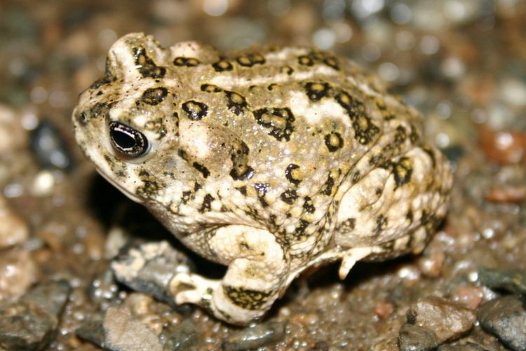
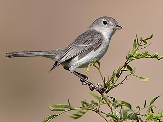
Two federally endangered animals are documented here. The arroyo toad — listed in 1994 — breeds in exactly the low, sandy, shallow-pool stream reaches the towers would cross; the plan conserves more than 1,602 acres of its breeding habitat. The least Bell's vireo — a riparian songbird listed in 1986 — nests in the willow and cottonwood thickets the right-of-way would clear. [3] [4] [1]
Because these species are federally listed, harming them or their habitat is a federal violation that triggers consultation with the U.S. Fish & Wildlife Service before anything can be built here — protections written for exactly this kind of place. [3] [4]
And the creek's reach runs downstream. Temecula Creek feeds the Santa Margarita River — designated critical habitat for the endangered Southern California steelhead, federally listed since 1997 and added to California's endangered list in 2024 — where a funded public effort is working to bring the fish back up the river. Sediment and disturbance from a creek crossing don't stay put; they travel downstream into that recovery. → See Temecula Creek & the Santa Margarita River. [5] [6]
A wildlife corridor already on life support
Temecula Creek isn't just habitat — it's the Santa Ana–Palomar Mountains Linkage, the last viable connection between the coastal Santa Ana Mountains and the inland Palomar range. That connection is already pinched nearly shut where Interstate 15 cuts through Temecula, and reopening it has been a regional conservation priority for some 30 years. [7]
Agencies, The Nature Conservancy, and local districts are spending millions to rebuild this crossing — including at the Temecula Creek I-15 bridge — because the Santa Ana mountain lions are headed for local extinction, by some estimates around 2050, if the corridor stays severed. Running a cleared transmission corridor, towers, and access roads along the very creek that is the linkage works against that effort. [7]
What the law requires
All of this triggers some of the strongest environmental law on the books: federal Endangered Species Act consultation (a Biological Opinion and incidental-take authorization) for the listed species, the California Endangered Species Act, and a formal finding that the project is even consistent with the MSHCP at all. For a line driven straight through a protected core area, that is a wall, not a formality. [2]
Combined with the water-crossing permits the same creek triggers, this is one of the project's hardest legal tests — and one of the clearest arguments that this is simply the wrong place for the line.
Sources
- [1]Western Riverside County MSHCP - Species Accounts & Core Areas — Riverside County TLMA / Regional Conservation Authority / City of Temecula
- [2]Western Riverside County MSHCP — program overview (reserve, covered species) — Western Riverside County Regional Conservation Authority (RCA) / USFWS
- [3]Arroyo toad (Anaxyrus californicus) — species profile — U.S. Fish & Wildlife Service (ECOS)
- [4]Least Bell's vireo (Vireo bellii pusillus) — species profile — U.S. Fish & Wildlife Service
- [5]Southern California Steelhead (Oncorhynchus mykiss) — NOAA Fisheries (National Marine Fisheries Service)
- [6]Southern steelhead listed as endangered under California's Endangered Species Act (CESA) — California Trout / California Fish and Game Commission
- [7]Santa Ana–Palomar Mountains Linkage & I-15 wildlife crossings at Temecula Creek — USGS (Vickers et al.) / Science for Conservation / The Nature Conservancy / Wildlife Crossing Fund
- [8]Temecula City Council presentation, May 26, 2026 (agenda item 19, AR-26-198) — SDG&E Golden Pacific Powerlink — City of Temecula